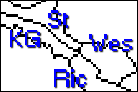
Stafford, Westmoreland, Richmond & King George ca1721
Old Rappa., Richmond, King George
& Westmoreland Counties VA

Stafford, Westmoreland, Richmond & King George ca1787
Stafford, Westmoreland, Richmond & King George ca1721 | The County Line Combs of Old Rappa., Richmond, King George & Westmoreland Counties VA | Stafford, Westmoreland, Richmond & King George ca1787 |
|---|
All of the following tracts of land lay between the Rappahannock River (the Southern boundary of Richmond & King George) and the Potomac River (the Northern boundary of Westmoreland and Stafford).
Some of the land lay in Old Rappahannock Co, VA, that part which later became Richmond, then King George. Some of the land traced below lay in Old Rappa., that part which later became and remained Richmond; and some of the land straddled Westmoreland and King George Counties.
Further complicating tracing of ownership of these land tracts: (1) Some creeks ran into the Rappahannock to the South; (2) some into the Potomac to the North; (3) most creeks experienced one or more name changes; (4) numerous changes in boundary lines also took place over the years, including, as is shown above right, an enormous change during the period 1777-1787; and (5) a number of records are not extant. Also note that when the land in this area became part of the "North Neck" (included all land North of Rappa. River) that numerous land owners "played it safe" by re-patenting their land. Note: See Also our new "still-in-beta-testing phase" Combs Deed Mapping Project. While no attempt has been made at yet to actually "deed map" any of these tracts (Volunteer Needed!), the above map (ca 1721) assists in showing the general area of this Combs' Neighborhood.
John Combs of Richmond (later King George), s/o Archdale & Elizabeth UNKNOWN (Underwood) (Underwood) Combs, owned more than 200 Acres on the north side of the Rappa. River, but exactly how much and how it was acquired remains unknown. The following records include only part of the tracts surrounding John Combs. Still missing is the all-important Underwood's Mill, which will not only further identify John Combs' land and neighbors, but will also "tie together" the land of his brother, William Combs, neighbor of William HAMMETT. (See Also Underwood Families)
(#1) Acreage: 200. Owners: John COMBS > Archdale COMBS > Ann COMBS Cope & Mary COMBS Dorsett & Mary UNKNOWN Combs > Richard & Mary UNDERWOOD Tutt
13 Mar 1696/7 (Richmond Co VA NN Grants No. 2, 1694-1700, p. 263) John COMBS 200 Acres beg. at a hickory by the river side on the line of a patent of one William YARRETTS now in the occupation of Mr. TANKARD and running along said line north, northwest, 12 purches to a stake and white oak thence along another line of YARRETS north, northeast, 3/4 of a degree East 320 purches to a red oak corner tree to UNDERWOOD & YARRETT, thence along a line of UNDERWOODS North 9 degrees, West 15 purches to a stake by small hickory thence West 15 degrees, North 102 purches to a white oak and a branch, thence south, southwest 3/4 of a degree West 308 purches to a Chestnut Oak upon the bank of the river on the Northwest side of a branch near Indian Needs Old Field, thence down the river its' several courses to the first mentioned station containing and being now laid out for 200 acres go together ye to have used to hold ye yielding and paying 4 shillings yearly ye provided ye dated the thirteenth day of March one thousand six hundred and ninety 6/7. W. F. GB. (Excerpted from original by Denise Mortorff, 1998) (Excerpted from original by Denise Mortorff, 1998).
27 Dec 1757 - 01 Jun 1758 (King Geo DB 4:323-325) Indenture made Dec. 27, 1757 between Henry COPE & Ann his wife, Mary COMBS & Mary DORSETT of King Geo. Co. of one part and Richd. TUTT of Spotsylvania Co. of the other. For 130 pds. current money of Virginia, sell all that parcel of land lying in King Geo. Co. containing 200 acs....corner to land formerly SMITHS and POPES now the land of Richd. TUTT party to these presents. /s/ Henry (X) COPE, Ann (X) COPE, /s/ Mary (X) COMBS Mary (X) DORSETT. At a court held June 1, 1758...Deed of Feoffment with Receipt endorsed...Ann assented and acknowledged the deed... (Sparacio)
Notes: The 200 acres patented above by John COMBS descended in 1717 to his son, Archdale COMBS II under laws of primogeniture (eldest son and heir) who bequeathed same in 1735 to his two daughters, Ann COMBS (COPE) and Mary COMBS (DORSETT) with his widow, Mary COMBS, holding a dower's right of 1/3 the property, the latter three being the grantors in the above deed.
(#2) Acreage: 6. Owners: Archdale COMBS > Mary UNDERWOOD Tutt
29 Apr - 01 May 1730 (King Geo DB 1-A:26-27) Apr. 29, 1730. Archabald COMBES of Hanover Par., King Geo. Co., to Mary TUTT of same, 1400 pds. of tobo. for 6 acs., all land contiguous to land whereon now liveth...beginning at mouth of a gutt running down the River... /s/ Archabald (X) COMBES. Wits: John GILBERT, Adam CUNNINGHAM, William (X) TUTT. 20 Apr 1730.. Livery & Seizin .. 1st May 1730 Deed & Livery & Seizin recorded. (KG DB A-1, Sparacio)
Notes: Archabald appears to have been a clerk's or transcriber's error for Archdale (Also probably seen in Stafford Co VA). The deed is not clear as to whether it is Archdale COMBS II or Mary UNDERWOOD (widow of Richard TUTT) who lives adj. to the 6 acres, but probably Archdale II. Given the low acreage, however, it is possible that this transaction is inconsequential. "Serious" deed mapping, however, might offer a solution. Also note that the TUTTS were buying up land all around them, and had been for years, plus Mary UNDERWOOD Tutt had inherited yet more land under terms of the will of her father, William (& Mary BUTLER) Underwood, Sr. (See Also Underwood Families)
(#3) Acreage: ??? Owners: John COMBS > Thomas Kendall
03 Jan 1692/3 - 6 Dec 1693 (Richmond Co DB 1692-1694:195-197 (97-100)) 3 Jan 1692. This Indenture made the 3rd day of January 1692 and in the Fourth year of the Reigne of our Sovereigne Lord & Lady, William & Mary, Between John COOMBES of Richmond County, Plantr., of the one part and Tho: KENDALL of the same County, Plantr., of the other part, Witnesseth that the sd John COOMBES for and in consideration of a Horse & a Sow & pigs to him in hand paid by the sd Tho: KENDALL before the sealing & delivery of these presents hath granted unto the sd Tho: KENDALL a parcell of land situate & being in the said County of Richmond on the north side of Rappa. River, beg. at a River and runnng to a Swamp and lying between the sd. Swamp & John WILLIS his land or the line of the sd John COOMBES with all houses buildings gardens orchards fences timber & water and all other the pr:mises belonging and all the Estate right & demand whatsoever of him the said John COOMBES unto the same; To have & to hold all & singular the said Land & pr:mises wth: all appurtinances to the same belonging unto the sd Tho: KENDALL his heirs & assigns forever more free & cleare from al former sales quit rents arrearages of rents & all other demands & incombrances made or done, the Quitrents henceforth to be due to his Majties: only excepted, by the sd Jno: COOMBES and that the sd Tho: KENDALL and his heirs shall from hence forth & forever hereafter quietly & peaceably possess & enjoy all & singulr the pr:mises as well against him the sd John COOMBES his heirs as against all other persons claiming under him or either of them and that the said John COOMBES and Ann his Wife will at any time acknowledge in open Court either to be held at the County Court or the Genrll. Court this Conveyance of the said Land & premises when thereunto requested by the sd Tho: KENDALL his heirs and at the cost & charges of sd Tho: KENDALL. In Witness whereof I the aforesd. John COMBES hath to this pr:sent Indenture sett my hand and seale. /s/ John ( crossed-I ) COOMBES. Signed sealed & delivered in the pr:sence of Tho: PARKE, Tho: [T] GOFFE. Recognitr: in Cur Com Richmond 6 die 10br: 1693
(Deed Abstracts of Richmond County, Virginia, 1692-1695, Ruth and Sam Sparacio, Antient Press, McLean, VA, 1991)
Notes: The failure to include acreage (in both the above deed and the next) is unfortunate to say the least. The above Thomas KENDALL was the same who was father (grandfather? research-in-progress) of William KENDALL who married John COMBS' daughter, Elizabeth. Thomas KENDALL had married Martha GOFF and the above Tho GOFFE may have been Martha's brother of the same name.
(#4) Acreage: 105 Owners: Thomas Kendall
19 Mar 1696/7 (NN Land Grant Book 2-265) Thomas KENDALL of Richmond Co. 105 A. on a Pocoson of Rappahanock River adj. Mary GUNSTOCKER, Indian, in the Clivis. Thomas GOFFE.. (VA NN Land Grants, 1694-1742, compiled by Gertrude E. Gray (GPC 1987)
02 Mar 1716/17 (Richmond D.B. 7-196). March 2, 1716-17, Thomas KENDALL of Parish of Hanover, Richmond Co., made a deed of gift to his son William KENDALL and his now wife Elizabeth [dau of John COMBS] of that plantation of 50 acres where said Thomas KENDALL now lives and whole personal estate to son William except what I have given to my youngest son, Samuel, provided that William live upon said plantation and maintain Thomas KENDALL during his natural life (S Williams, Researcher)
Notes: Not yet known if to which of the 1st 2 deeds the above deed references.
(#5) Acreage: ?? Owners: John Willis > Thomas Kendall
03 Jan 1692/3 - 06 Dec 1693 (Richmond Co, Records, 1692-1704, p. 97) Deed. John WILLIS of Richmond Co, planter, to Thos KENDALL of the same Co., planter, for certain cattle, a parcel of land in Richmond Co., 'being between the land of [Indrein & Joseph MASON per Fleet] or [Indian MASON & Joseph MASON per Sparacio*], "beg. upon the River & running to the first Swamp not proceeding over the Run & going up the said Run to an Indian Path & not proceeding over the said Path, this by Agree-mt. of both parties was written before the seale was signed." Signed John [mark] WILLIS. Wit: Tho PARKE, Tho [x] GOFFE. Dated 3 January 1692/3. Rec. 06 Dec. 1693. (Richmond Records, Sparacio & Virginia Colonial Abstracts, Vol 1, Beverly Fleet, GPC, 1988, p. 252; extracted by C. Hammett, 1998) *ch: Whether the clerk recorded as "Indrein" or "Indian MASON," the reference was undoubtedly to "Edward 'Ned' GUNSTOCKER, Indian." Also note: Acreage not given.
(#6) Acreage: 210 Owners: John Willis
19 Mar 1696/7 (VA North Neck Land Grant Book 2-264) John WILLIS of Richmond Co. 210 A. beginning at a marked hickory, corner tree to this land and the land of Mary GUNSTOCKER Indian, standing upon upon Rappahanock River side in the Clivis, extending thence N 6 degrees, E 160 poles to a marked white oak, corner tree to this land and the land of the said GUNSTOCKER, thence NW 80 poles to a marked red oak, corner tree on the lines of the land of the said GUNSTOCKER, and dividing this land from the land of Thomas GOFFE, thence N 4-1/2 degrees, E 158 poles to a marked locust corner tree, thence S 76 degrees, E 211 poles to a marked white oak, corner tree to this land and the land of John COMBS, thence S 29-1/2 degrees, W 322 poles to a marked Corner Chestnut oak standing by the said River thence along the said river side to the dwelling house, the aforementioned beginning place. (Transcribed by Combs Researcher C. Hammett, 1998)
(#7) Acreage: 105 Owners: Thomas Goff > Isaac Arnold (40 Acress)
19 Mar. 1696/7 (NN Land Grant Book 2-266) Thomas GOFFE of Richmond Co. 105 A. beg. at a marked corner, white oak, to the land of Thomas KENDALL, standing in the back line of Mary GUNSTOCKER in the Clivis extending thence NE 107 poles to a marked red oak corner tree to this land and the land of Mr. John WILLIS standing in the said GUNSTOCKS line, thence N 76 degrees, W 90 poles to a marked white oak upon the east side of the pocoson swamp near the head of Warasque Creek, thence down the meanders of the said Swamp to a marked Spanish oak dividing this land from the land of the said KENDALL being on the said Swamp, thence S 4-1/2 degrees, W 113 poles to the aforementioned beg. containing and being now laid out for 105 acres together…. 19 mar 1696/7
(VSLA Land Records, Transcribed/abstracted by C. Hammett)
28 Feb 1707/8 - 5 May 1708 (Richmond DB4:129a-130) Indent. 28 Feb 1707/8. eighth and twentyeth day of Febry. in the fifth year of the Reigne of our Sovereigne Lady Anno by the Grace of God of England Scotland France and Ireland, Queene defender of the faith &c. and in the yeare of our Lord God one thousand seven hundred and seven Betweene Thomas GOFFE of the Parish of St. Marys in the County of Virginia, Planter…unto Isaac ARNOLD of same.. Thomas GOFFE in consideration of a Marryage already had and solemnized betweene him the said Isaac ARNOLD and party to these presents and Margarett his now Wife, Daughter of aforesaid Thomas GOFFE and also for the naturall love and affection which Thomas GOFFE now hath and beareth to and towards his said Daughter and for her Advancement and settlement by way of Marryage and for the settling and Establishing the promises hereafter mentioned in the blood and posterity of the said Isaac ARNOLD and Margarett his Wife as long as it shall please to continue the same and for other good cause and considerations him the said Thomas GOFFE thereunto att this time especially moving, doth bargaine sell and confirm unto Isaac ARNOLD and his heires all that messuage or tenement where Isaac ARNOLD now liveth and inhabiteth, together also with Forty acres of land or thereabouts to the same belonging scituate in the Parish of St. Marys in the County of Richmond beginning att a Wallnutt being the dividing line betweene John WILLIS, Junr. and Thomas GOFFE party to these presents, running thence to a Locus tree dividing the land between the said John WILLIS and Thomas GOFFE, thence to a red Oake in GUNSTOCKERS line, thence to a small red Oake in GUNSTOCKERS Line, thence N 4-1/2d. East one hundred fifty eight poles to the first beginning with all houses tobbacco houses barnes orchards and edifices whatever… all timber trees and trees likely to make timber, the premises being part of a Pattent granted by the Agents of the Proprietors of the Northern Neck of Virginia for One hundred and five acres of land or thereabouts to said Thomas GOFFE… date 19 Mar 1696… the use of Isaac ARNOLD during the terme of is naturall life and from and after his decease to the use of said Margarett his Wife during the teme of her naturall life and after the death of the Survivour of them, to the use of Isaac ARNOLD Junr. Son of the said Isaac, party to these presents, and Margarettt his Wife… day month and yeare first above writen. S/Thomas [his marke T] GOFFE. Wits: John HOAXFOARD, William DUFFE [T his marke], E. TURBERVILLE. John HOAXFORD by virtue of a Power of Attorney from Thomas GOFFE and Margarett his wife, acknowledged this Deed in Richmond County Court ye 7th day of Aprill Ano Dom: 1708… Test. J. SHERLOCK, Cl. Cur.
Richmond Sct. Thomas GOFFE of the Parish of St. Marys in the County of Richmond, Planter, and Margarett his Wife do put in theire place John HOAXFORD theire Attorney… to acknowledge a Certain Deed made by him the said Thomas GOFFE to Isaac ARNOLD for Forty acres of land beareing the date wth: those presents and the said Margarett, the Wife of said Thomas, do hereby also impower said John HAUXFORD [sic] to relinquish my right of Dower… this 28th February Ano: Dom: 1707. S/ the marke of Thomas [T] GOFFE, Margarett her marke [O] GOFFE. Rec. amongst the Recs. of Richmond County Court. Test. J. SHERLOCK. Cl. Cur
(Deed Abstracts of Richmond County, Virginia, 1705-1708, Deed Book No. 4, Ruth and Sam Sparacio, Antient Press, McLean, Virginia, 1991)
(#8) Acres: 2000 Owners: Nicholas Merriweather > Capt. Henry Fleet > Henry Fleet >
Notes: See Next Deeds for transactions. Henry FLEET was the s/o Capt. Henry & Sarah UNKNOWN Fleet, Sr. Following the death of Henry FLEET, Sr., his widow, Sarah, m (2) Col. John WALKER of Gloucester & Old Rappahannock Co VA; m (3) John STONE. (See Boughton-Fleet-Scott Families)
(#8a) Acres: 150 Owners: Edward "Ned" Gunstocker, Indian > Mary Gunstocker? > ?
14 Oct 1665 (Rappa. - Virginia PB5:536(657)) Nedd GUNSTOCKER, Indian, 150 acres Rappahannock. Co., North side of the [Rappahannock] River in the freshes, Beg. nere a branch called Comistanck on the Eastermost side, running N. by E. &c. to a marked ash nere a branch called Weequionedike &c. and Granted by order of the Govr. &c. bearing date herewith, & further due for trans. of 3 pers: Henry BARDELL, Tho. COOPER, Jno. FOWKE. (Cavaliers & Pioneers, Vol. 1, Nugent, pp. 566-7) Search Words: BARRADALL.
28 Oct 1682 - 23 Sep 1683 (Old Rappa. DB7:69-70) Edward GUNSTOCKER of Rappa. lease to John EASTER and Wm: GEERE of same land GUNSTOCKER now liveth on… 10 year term.. S/Edward [his mark] GUNSTOCKER, John [JE] EASTER, Wm. GEERE; Wits: Wm. UNDERWOOD, Saml: [SB] BOWEN his marke. (Old Rappa. Deed Book, 1682-1686, Ruth and Sam Sparacio, Antient Press, McLean, VA)
Notes: No deed from Gunstockers found yet; however, see also references to Mary Gunstocker. Also note that Christopher BLACKBURN sold other lands to William GEERE in 1666 (Old Rap. Co., Virginia DB 3:127-7), in regard to which Abraham COMBS witnessed one of several records.
(#8b) Acres: 100 Owners: Peter Butler
Note: Transaction not found yet other than in other Henry FLEET deeds identifying transaction as pre 13 Aug 1684, and 100 A. adj. to Henry FLEET'S land & land of Edward "Ned" GUNSTOCKER & Joshua MASON; thence Malachi PEALE & Edwin CONWAY.
(#8c) Acreage: 200 Owners: Joshua Mason
Note: Transaction not found other than in other Henry FLEET deeds identifying transaction as pre 13 Aug 1684, and 200 A. adj. to Henry FLEET'S land & land of Edward "Ned" GUNSTOCKER & Peter BUTLER; thence Malachi PEALE & Edwin CONWAY.
(#8d) Acreage: 300 Owners: Malachi Peale
13 Aug 1684 - 04 Nov 1686 (Old Rappa. Deeds, 1686-1688:277-278) Indent. Henry FLEET of Northumberland [VA] Gent. and Elizabeth his wife of the one part and Mallachy PEALE of County of Stafford also Gent. of the other part £45 sterling consideration land in Parish of St. Mary's in Co of Rappa. and on N side of the River in the Freshes, bounded as is expressed in a certaine survey thereof made and dated 13th Mar 1683/4 as follows: Beg at pohickory by the River side in the line of TANKARDS and running thence by the sd River its severeall courses to Indian Neds land out of this survey he holding (by Reputation) 150 A, thence continuing its several courses up the River to a white Oake at the mouth of a small Creek neer Warasquik Indian Town, thence up the sd Creek and Maine Branch its severall courses to the extent of a mile being to a white Oake of the Mane Branch side, thence over the hills East to a Stake in Mr. UNDERWOOD'S line by a small Hickory, thence to a corner tree of UNDERWOOD'S and TANKARDS SW thence along the sd TANKARDS line SSW to a Stake pr a White Oake corner tree to sd TANKARD, thence to the first mencioned Hickory in SSE which said land amongst other lands was Pattented by Lt. Collo. John WALKER dated 21 Sep 1663 and all …. to the sd granted land belonging (except and allwaise released out of this present Grant Two hundred acres of land part of the sd. surveyed land granted by Henry FLEET to Joshuah MASON and also all the land called Indian Neds)… s/Henry FLEET, Elizabeth FLEET, Samll. TRAVERS, Robt. TOMLIN, Jnr…. authorizes Mr. John TAVERNER attorney 3 Nov 1686… s/Henry FLEET. Wits: John RICE, Samll. SAMFORD. Record 13 die Jul 1686. At a court Rappa. 3 Nov 1666 Mrs. Elizabeth FLEET did ackn. Mr. Wm. TAYLOE and Mr. John TAVERNER her Attorney… Recog 4 Nov 1686…. Mallachy PEALE auth Joshua DAVIS to appear in Rappahannock to receive ack. from FLEET… 3 Nov 1686. s/Mallachy PEALE; Wits: John RICE, Samll. STANFORD [sic]. Recordr 13 Nov 1686. (Old Rappahannock Records, Ruth & Sam Sparacio, McLean, VA)
(#8e) Acres: 1250 Owners: Edwin Conway
05 Sep 1694 (Richmond DB2:59-61) Henry FLEET of Christ Church Parish, Lancaster, Gent, to Edwin CONWAY, of same, also Gent… 11 pds. 6 shillings current money of EN… 2000 A Co of Richmond bounded on SE by Falling Creek, S & SE upon River of Rappa., NW upon small Creek near Wasasquit Indian Town, NE upon the Hills there which sd land formerly granted to Nicholas MERIWETHER Pat. dated 13 Apr 1655, by him sold 8 Sep 1656 to Capt. Henry FLEET, father of sd Henry FLEET (except reserve 200 A of the said Tract of land granted to one Joshua MASON & 100 A to Peter BUTLER & 300 A to Malachi PEALE by sd Henry FLEET)… Henry FLEET and his wife Elizabeth… S/Henry FLEET; Wits: John STONE & Jno: TAVERNER. Recog 5 Sep 1694 & recordr 15th die. (Richmond Deeds, 1692-1695, DB1 & DB2(part), Ruth & Sam Sparacio, The Antient Press, McLean, VA, 1991)
(#9) Acreage: 154 Owners: John Willis & John Parsons > John Willis, Jr. & John Parsons, Jr. > Walter Anderson
27 Feb 1690 (NN PBA:43-4) John WILLIS & John PARSONS, both of Rappa. Co. 154 A. in sd. Co. adj. to a tract of land surveyed for Henry FLEETE above FOXALLS Mill. 27 Feb 1690. (Cavaliers & Pioneers, Abstracts of Virginia Land Patents and Grants, Supplement Northern Nck Grants No. I, 1690-1692, Nell Marion Nugent, Virginia State Library, Richmond, 1980)
26 Oct 1698 - 22 Nov 1698 (Richmond DB2:36) John PARSONS of the County of Essex to Waltr: ANDERSON of the County of Richmond, land in Richmond more or less being "my full share or part of a greater tract taken up by my Father, John PARSONS, & John WILLIS, Senr. in Copartnership as will appeare by Patent granted them for the same by Phillip LUDWELL, Agent for the Proprietors, dated the 27th of Feb 1690/1"… all edifices houses orchards & gardens & fences thereon… d/26 Oct 1698. S/John PARSONS his marke [sic]; Wits: Fonx. JONES his marke, Nathll. POPE. Recognitr: 2d Nov 1698 and Recordr: 22nd. (Richmond Deeds, 1695-1701, Sparacio) Note: John PARSONS' will may be in records of Essex County.
21 Mar 1706/7 (Richmond DB4:102a-103) Whereas John WILLIS and John PARSONS both of Co of Richmond seized in joyntennancy in One hundred fivety eight acres of land lying in St. Marys Parish in County aforesd as may appeare by a Patent under the hand of Phill: LUDWELL Esqr. then Agent and Attorney to the Proprietors and Seale of theire Office dated the Twenty seventh day of Feb 1690/1: and Whereas John PARSONS dying did by his last Will and Testament give his part of the said Land to his son, John PARSONS, and Walter ANDERSON, and the said Walter ANDERSONS having purchased the said John PARSONS part by meanes whereof Walter ANDERSON hath good right to all the said parcell of land said John PARSONS dyed seized of: And John WILLIS did by Deed grant his part of the said land to his Son, John WILLIS, so that the whole land now belongs to the said Walter ANDERSON and John WILLIS, Junr. And now to the end that no advantage of Survivorship shall be, the said parties hath caused this Instrument of Writing to be made declareing that the division of said land be beginning upon FLEETS line and so up the Branch that runs through the said land being the Division line that said John PARSON and John WILLIS formerly held, the Estermost part of which the said Walter ANDERSON and his heires for ever to hold, and the Westarmost part to be held by John WILLIS Junr. and his heires wholly disallowing any right of Survivorship already past or to come… D/21 Mar 1706. S/John WILLIS Junr, Walter his marke [A] ANDERSON. Wits: Richard CRADDOCK, Nathl. POPE. Recog. 2 Apr 1707 & Recordat 15th die. Test J. SHERLOCK, Cl Cur. (Richmond Deeds, 1705-1708 (DB 4), Sparacio)
Notes: The above Walter ANDERSON was either the brother or father of John ANDERSON, co-exec. of the will of John COMBS (See Next)
(#10) Acreage: 200 Owners: Original & Jane BROOKS Browne
4 Apr 1678 (VA Land Patent Book 6:631) Originall BROWNE, 200 Acres in Westmoreland Co VA bet. Potomacke & Rappa.. Rivers, Beg. at land of John WILLIS; along Mr. John FOXHALL; to Ned the Indians path; along Lt. Col. John WASHINGTON, &c. Trans. of 4 pers: William BROWNE, Robert MIDLETON, Jos. ROGERS, Willi MORGAN.
(Cavaliers & Pioneers, Vol. II, Nugent, p. 181) [sw: middleton]
Notes: Original BROWN m Jane BROOKS. Of their children, Jane m Nathaniel POPE; Judith m William WROE and Mary may have m John ANDERSON, co-executor of the will of John COMBS. (See Brown-Pope-Wroe Families) John FOXHALL, Sr., b in Co Essex, EN, was father of (among others) Mary FOXHALL, whose first husband, Robert VAULX, was a Quaker, and whose second husband was Alexander GORGES, whose relationship (if any) to the Archdale-Gorges Family, remains unknown. (See Foxhall Family)
(#11) Acreage: 580>454 Owners: William Yarrrett & Francis Whittington > John Tankard > Nathaniel Pope & Nicholas Smith
29 Jul 1650 (VA Patent Book2:216) William YARRETT & Francis WHITTINGTON, 580 A N. side Rappa. Riv., next above land of Robert BIRD. 20 A. still due upon last name in certficate. Trans. 12 pers.: Richard READ, Samll. CLARKE, Antho. LITTLE, wife of Amb. PROCTER, John BEIFE, Mary BURBANCK, Tho. GWALPMEY, Thomas MEARES, Robert PERFECT, wife of Robert PERFECT.
(Cavaliers and Pioneers, Vol. 1, Nugent, p. 191-2)
29 Jul 1650 - 18 Jun 1700 (NN PB2:320) William YORRETT of Rappahannock Co. since Richmond Co. obtained 580 acres from Sir William BERKLEY, Gov. of Va. 29 Jul 1650. YORRETT died. Land Escheated. Nathaniel POPE als: BRIDGES of Richmond Co. St. Mary's Parish Escheat. Grant. Resurvey shows only 404 [nb: 454?] A. in Richmond Co., St. Mary's Parish., adj. land of Mr. Robert BIRD now in possession of Mr. William UNDERWOOD.
(Virginia North Neck Land Grants, 1694-1742, Vol. I, compiled by Gertrude E. Gray, GPC, Baltimore, 1987)
29 Jul 1650 08 Jun 1710 (Richmond Co, Records, 1704-1724:56) "Richmond Sc't Prusuant [sic] to an order of Court bearing date the 8th June 1710 Wee whose names are under written being summoned as Juryers in a difference between capt'n Nicholas SMITH and m'r Nathaniell POPE plts and John COMBS and Henry JAMES Defend'ts have surveyed the land of the plts: it being a patent granted to Wm YARRETT and Francis WITTINGTON for five hundred and eighty acres dated the 29th July 1650 and wee find one of the Def'ts (Viz't) Henry JAMES a Trespasser the sum of five shillings sterling. Witness our hands this twenty first of June 1710" George PAYNE foreman, Thomas RICHARDSON, Tho x BROCKS marke, Fra: JAMES x, James SCOTT, John MASON x, Joseph MELLINTON his marke, Charles CHILL, Thomas PAISE, John JENINGS, Cornelius EDMUNDS, George ERWIN, Wm THORNTON Sur'y'r.
(Virginia Colonial Abstracts, Vol 1, Beverly Fleet, GPC, 1988, p. 271)
Note: The above William YARRETT, like the UNDERWOODS & MEADORS, was earlier in Isle of Wight Co VA. Unlike the other families (so far as we know), William YARRETT was a Quaker. John TANKARD, to whom YARRETT sold this property, is earlier found on the Eastern Shore where, in 1678, he witnessed the will of Capt. John SAVAGE whose dau. Susan had m William KENDALL (rel. to Richmond Co VA KENDALLS, if any, unknown), and who named a Jarvis COOMBES in his will.
(#11a) Acreage: 580>454 Owners: William Yarrrett & Francis Whittington > John Tankard > Nathaniel Pope & Nicholas Smith > (1/2) Nathaniel Pope > Nathaniel Pope, Jr. > John Pope > Richard Tutt, Jr.
29 Jul 1650 - 20 May 1753 (King George DB4:30-35) Indenture made 20th/21st May 1753 between Nathaniel POPE and Lucy his wife of county Louisa and Richard TUTT of Spotsylvania County Gent. . by deeds of lease and release .. for sum Two hundred and twenty seven pounds current money of Virginia .. sold parcel of land I parish Hanover in county King George adjoining land of said Richard TUTT containing 227 acres it being part of a tract of land formerly granted to William YARRETT and Francs WITTINGTON by Patent dated 29th July 1650 for 580 acres but by later survey 1st July 1712 by William THORNTON then Surveyor of Richmond County .. was found to be only 454 [nb: 404?] acres which by several more conveyances became Fee Simple estate of John TANKARD of county Northampton planter who by deed dated 11th January 1708 conveyed same to Nicholas SMITH and Nathaniel POPE .. divided by them on 1st day July aforesaid .. deed duly acknowledged in Richmond County Court .. above mentioned 227 acres is lower or Eastermost part allotted said Nathaniel POPE and is now the Inheritance and Fee Simple Estate of Nathaniel POPE party to these presents grandson to said Nathaniel and son and heir at law of John POPE his son ..Nathaniel POPE, Lucy POPE. Presence Frans. TALIAFERRO, Rd. BROOKE, Thos. TURNER Junr., Lucy POPE, Jo. FOX, Lawrence TALIAFERRO, James TUTT, William BARKSDELL. At a court held 2nd August 1735 .. deeds of lease ad release and Receipt endorsed by Nathaniel POPE and Lucy his wife admitted to record.
(King George Abstracts, Deed Book 4, 1753-1765; Deed Book 5 (partial) 1765-1773; Poll list recorded 15 Dec 1755, Ruth and Sam Sparacio, Antient Press, McLean VA 22101, 1987)
(#11b) Acreage: 580>454 Owners: William Yarrrett & Francis Whittington > John Tankard > Nathaniel Pope & Nicholas Smith > (1/2) Nicholas Smith > William Smith > John Piper
Notes: Not traced yet, but see Original BROWN'S Tract #10 above.
(#12) Acreage: 300 Owners: William Underwood Sr. > Nathaniel Pope alias Bridges > Nathaniel Pope > John Pope > Joshua Farguson
18 May 1685 (Rappahannock Records, Vol. 1682-88, p. 202) William UNDERWOOD of Sittingbourne Parish, Rappahannock County, on May 18, 1685, acknowledged a bond to Nathaniel POPE of Westmoreland County for the sum of 15,000 pounds of good merchantable tobacco and cask. The said UNDERWOOD hath sold unto said POPE a tract of land containing 300 acres of the tract UNDERWOOD now lives on, near the line of John WILLIS, running on said line next to Potomac including a level of land by the burnt poplar, including the plantation and houses thereunto belonging - William UNDERWOOD and Joane his wife to acknowledge this sale to Daniel WHITTY [WHILLY per Sparacio] and Mary his wife at the next court for Rappahannock County on the North side of the River on behalf of Nathaniel POPE and shall at any time when required make such conveyance as shall be lawful to the said POPE. Witnessed by Francis TRIPLETT, Charles PORTER
(Genealogies of Virginia Families, Fothergill, who transcribed WILLS, not Willis (Sparacio)
03 Aug 1696 (Richmond VA DBII:188) William UNDERWOOD of Richmond County to "Nathaniel POPE als BRIDGES" a tract of land containing 300 acres lying in the freshes of Rappahannock River, being part of the land on which said UNDERWOOD now liveth, near the Rappahannock Road over the main branch of FOXHALLS Mill Dam, in the back line next to Potomac as granted to the said UNDERWOOD
(Richmond Deeds, Bk II, p. 188, Underwood, Fothergill).
3/4 Aug 1730-7 Aug 1730 (King George DB1-A:64-69) Indent. John POPE of Washington Parish, Westmoreland Co, VA to Joshua FFARGUSON of Hanover, KG County, £30, land whereon Joshua now live, 80 A, being all that remaineth of 300 A. formerly sold by Capt. Wm. UNDERWOOD Gent of County of Richmond Deced unto Nathaniel POPE alias BRIDGES Father to said John POPE.. said UNDERWOOD by deed bearing date 3 Aug 1696 said 80 A in Parish of Hanover bounded by land of Jeremiah MURDOCH; Abraham BLAGG; BLAGG'S Line, along former line of William UNDERWOOD deced to Nathaniel POPE to first mencd. station. also with the remaining part of 100 A. bought by William WHEELER sold to Nathaniel POPE Father to John POPE.. UNDERWOOD'S deed bearing date 4th Dec 1689 .. 80 A as also parcell remaining of the 100 A... To have and to hold John POPE doth hereby promise that the above sold land against claims of John PIPER & William ROE their heirs... s/John POPE, Presence Josiah FARGUSON, Moses [x] KNIGHTON. Ackn. by John POPE 7 Aug 1730... & Thos. TURNER w/POA from Elizabeth POPE wife of said John ... relinquished her right of Dower... s/Elizabeth [x] POPE, Wits: John [x] BURCH, George PARSONS. 7th Aug 1730.. (Sparacio) The above was Abraham BLAGG III. See Also Abraham BLAGG I in records of St. Mary's Co MD with Abraham COMBS of Old Rappa. Co VA & St. Mary's Co MD. Abraham BLAGG I m Margaret WEIRE, d/o Maj. John & Honoria UNKNOWN Ware (Jones)
(See Also Burroughs-Vassall-Ware Families)
(#13) Acreage: 64 Owners: John Wheeler
05 Oct 1694 (VA NN Bk 2:19) John WHEELER, 64 acs. in Westmoreland Co. near the land of Pope's Crk, beg. at a marked (locust?) standing on the N Line of a small run that falls into the Land of Popes Creek and runneth (between) this land and the land of William KIMBER and extending up the land of George SAYWARD NE 140 poles to a marked oak standing in John FOXHALL'S line, then along the said line WNW 140 poles to another oak, thence SSW to a white oak standing on the N Line of the aforesd…. 48 poles, finally down the river to the first beginning. Wrnt. Oct. 5, 1694. Adj. Wm. KIMBAR [KENDALL?], Geo. SAYWARD & John FOXHALL.
(VSLA, Abstracted by C. Hammett, 1998)
(#14) Acres: 100 Owners: William Underwood, Sr. > William Wheeler, Sr. > William Wheeler, Jr. & John Wheeler > William Wheeler, Jr.
04 Dec 1689 - 17 Mar 1689 (Richmond DB4:86a-87a) William UNDERWOOD, 3000 pds. tobo. to William WHEELER, 100 A of Woodland Ground being bounded beginning at the corner tree of Nathaniel POPES land next to the land of John PIPER, and so along that line to the length as shall containe the said hundred acres square… hand and seale 4th day of Dec Ano. Dom: 1689. S/Wm. UNDERWOOD; Wits: Anthony RALLINGS [WALLIS per Fothergill], Joseph HEMINGS. Prvd. 5 Martii Ano. 1689 & Rec. 17th die. Test. Wm. COLSTON, Cl Cur. Rec. Cur. Com Richmd. 12th Febry Ano: 1706. Test J. SHERLOCK, Cl Cur.
Know all men by these presents that I John WHEELER of County of Stafford have bargained and sole unto my Brother, William WHEELER of the County of Westmoreland the moity of One hundred acres of land wch: my father, John WHEELER bought of Mr. William UNDERWOOD Gent. as within specified and left to me by my Father's Will and I do acknowledge to have received full satisfaction for my part of the land of my foresaid Brother with houses orchards and all other priviledges belonging and further I do warrant the sale of the said plantation unto my Brother William WHEELER … hand and seale 8 day Nov 1706. S/John his marke [W] WHEELER. Wits: Joseph HEMINGS, Robert RANKINS.
Ackn. in Richmond County Court by Walter ANDERSON, Atto. of John WHEELER and Sarah WHEELER the 5th day of Febry 1706 and rec. 12 day of same moneth and yeare. Test. J SHERLOCKE, Cl. Cur.
(Sparacio)
(#15) Acreage: 150 Owners: Nathaniel & Jane BROWN Pope > William & Judith BROWN Wroe
02 Feb 1702/3 (Richmond County, Virginia DB 3:206-208) KNOW ALL MEN by these pr:sents that I Nathaniell POPE of Westmoreland. County, Prectioner & Law, for divers good causes and considerations me hereunto moveing but more especially for and in consideration of the Love I beare unto William ROE and Judeth his Wife and theirs Children, have given unto the said William ROE and Judeth his Wife, one peice or parcell of Land scituate and being in the County of Richmond part of the Devident of Land I formerly lived on now in the occupation of Walter ANDERSON, begining in the line next to Pottomack att a marked Hickory standing close by the Path that goes by the burnt Poplar Stump and standing close by the said Poplar Stump and running along the said path about one hundred and fifty yards to a small valley called the Dogwood Valley and so downe the said Valley and the meanders thereof to the uttmost extent of the said land by estimation one hundred and fivety acres be the same more or less, I say that part of the said Land next and adjoyning to the land formerly belonging to William WHEELER now in the occupation and tenure of John PITTMAN, with all woods and underwoods houses fences orchards and gardens thereon to the said William ROE and Judith his Wife for and dureing their naturall life and after their decease to their Son, Originole ROE and the heires of his body lawfully begotten forever, And for want of such issue to the next male issue of the body of the said William and Judith forever, And for want of such issue to the Eldest Daughter liveing of the body of the said William and Judith begotten and her heires forever; To have and to hold the said Land to the said William ROE and Judith for their lives as aforesaid and after theire decease as is aforementioned. Wittness my hand and scale this 2d: of Febry: 1702; And further I do warrant the said Land from the claymes or molestation of any persons yt: may or shall clayme the same by or under me. s/Nath: POPE. Signed sealed and delivered in pr:sence of Robt. PAYNE, Jonas (mark) SCOTT. Recognitr in Cur: Com: Richmond 3d: die Febry, 1702 & recordatr 6th: die. Teste James SHERLOCK Cl Cur
Know all men by these presents that I Jane POPE do assigne and make over my right of Dower of the within land according to the express Deed within mentioned. Wittness my hand and seale this 2d: day of Febry: 1702. /s/Jane POPE. Sealed and delivered in presence of Robt. PAYNE, Jonas (mark) SCOTT. Recordatr: Test James Sherlock, Cl Cur.
(Deed Abstracts of Richmond County, Virginia, 1701-1704, Ruth & Sam Sparacio)