Old Rappahannock Co, VA
Descendant Counties of
Old Rappahannock VA
|
| Combs Land of Old Rappahannock Co, VA | Descendant Counties of Old Rappahannock VA |
|---|
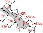
Old Rappahannock County was established from Lancaster County (La) in 1656; however, no record of any Combs owning property or residing in Lancaster has been located thus far. In 1692, Old Rappa. was divided into two counties, Essex (Es) on the South side of the Rappa. River, and Richmond (Ric) on the North side, and Old Rappa. itself abolished. In 1720/1, King George (KG) was established from Richmond & Westmoreland (Wes) ; and Spotsylvania (Sp) from Essex, King and Queen (KQ) and King William (KW). In 1728, Caroline was established from Essex, King and Queen and King William; and in 1730/1, Prince William (PW) was organized from King George and Stafford (St) .
Over the years a number of further boundary changes took place, including extensive exchanges between King George and Stafford, and King George with Westmoreland. The above map, however, is a "rough" representation of Virginia's North Neck ca 1730. The following is an index to various parcels or areas of Combs' (& Combs-Associated) Land in what was originally Old Rappa. Co VA. It is still incomplete, but a start toward closer identification of properties and neighbors.
| Index to Combs &c. Land in Old Rappa. Co VA | ||
|---|---|---|
| Combs Owner(s) | Later County(ies) | Land |
| John, William & Mason | Essex > Caroline | Peuman's End Run |
| Archdale | Unknown | The Forest |
| John | Richmond > King George | County Line |
| Charles | Essex | The Forest |
| Emmanuel | King George > Prince William | ??? Marsh |
| William | Richmond | |
| Archdale II | Essex > Spotsylvania | Not Yet Found |
| William UNDERWOOD | Richmond > King George | Underwood's Mill |